
Current real estate market data, news and analysis for the Cape Girardeau, MO-IL metropolitan area — 99,215 residents across Alexander, IL, Bollinger, MO and Cape Girardeau, MO counties.
Data as of May 2026. Sources: Redfin Data Center, U.S. Census Bureau.
Latest Cape Girardeau Real Estate News
Coverage of this market is coming soon. Browse all housing market news.
Cape Girardeau Real Estate Market Overview
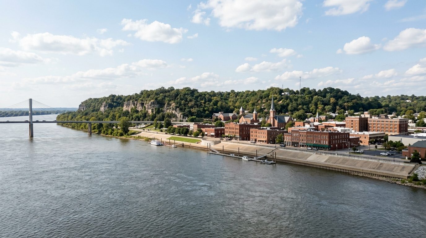
Cape Girardeau sits on limestone bluffs above the Mississippi River, at a bend where the river forms the Missouri-Illinois state line. Downtown sits low enough that a permanent floodwall and levee separate the historic riverfront district from the water, with a long mural covering the wall along the riverfront promenade. Away from the river, the land rises into rolling, wooded hills typical of the Ozark foothills rather than the flat farmland farther south in the Bootheel. Housing stock reflects this history: neighborhoods near downtown hold narrow-lot Craftsman bungalows, cottages, and early twentieth-century frame houses, several within locally designated historic districts with preservation review for exterior changes. Postwar ranch and split-level homes fill the blocks toward the city’s outer edges, while the newest single-family construction sits on larger lots on the west and southwest edges of Cape Girardeau and around Jackson. Rural towns in Bollinger County and on the Illinois side lean toward older farmhouses and modest homes.
Price tiers generally track distance from low-lying river ground and the age of the housing stock. Jackson and the newer subdivisions on Cape Girardeau’s west and southwest sides trend toward the higher end, reflecting recent construction, larger lots, and continued residential growth along the highway corridor. Restored homes in historic districts such as the Boulevard and Courthouse-Seminary areas can carry a premium for period architecture and downtown proximity, but low-lying ground near the river, including parts of Red Star where the city has bought out flood-damaged parcels, trends lower. On the Illinois side, towns such as Cairo, East Cape Girardeau, Tamms, and Thebes sit toward the lower end, reflecting long-term population decline, older housing stock, and levee concerns near the Ohio-Mississippi confluence. Smaller Missouri towns fall in between, tied to commute distance from the two main cities.
The regional economy centers on education, health care, manufacturing, and the city’s role as a trade hub for southeast Missouri and southern Illinois. Southeast Missouri State University is a major anchor, both as an employer and as a draw for rental demand tied to enrollment. Health care is a leading sector, led by Saint Francis Healthcare System and SoutheastHEALTH, which operates Southeast Hospital and area clinics serving patients from beyond the metro. Procter & Gamble operates a manufacturing facility locally, adding an industrial base alongside other manufacturers along the Interstate 55 corridor. As the largest city between St. Louis and Memphis, Cape Girardeau also functions as a regional retail and medical destination for a multi-county, cross-state trade area.
Several regional factors are worth understanding before buying. The metro lies near the New Madrid Seismic Zone, a source of periodic earthquake activity; damaging events are infrequent, but buyers may want to ask about a property’s foundation type and seismic-related building requirements. Flood risk is a live consideration near the Mississippi and Ohio Rivers: downtown Cape Girardeau and Cairo’s core are protected by levees and floodwalls, but low-lying parcels outside those protections can carry flood-insurance requirements worth checking with local officials. Because the metro spans two states, property tax structures and assessment practices differ between the Missouri counties and Alexander County, Illinois, so buyers should confirm local rates directly. The metro has no large public transit system, so most residents drive, and buyers should verify which school district, municipality, and utility provider serves a given property.
Cities and Towns in the Cape Girardeau Metro Area
Notable Communities and Neighborhoods
Cape Girardeau Real Estate Market FAQ
How is the Cape Girardeau metro organized geographically?
The metro straddles the Mississippi River where it forms the Missouri-Illinois state line. Cape Girardeau and Jackson anchor the Missouri side on bluffs and rolling terrain above the river, while Bollinger County towns sit further inland to the west. The Illinois side includes smaller river towns near the confluence of the Ohio and Mississippi Rivers, including Cairo, East Cape Girardeau, Tamms, and Thebes, which are more rural and river-oriented than the Missouri core.
Which areas in the metro tend to be pricier, and why?
Newer subdivisions on the west and southwest sides of Cape Girardeau, along with the growing city of Jackson, trend toward the higher end because of recent construction, larger lots, and ongoing residential development along the main highway corridor. Restored homes in Cape Girardeau’s designated historic districts can also carry a premium tied to period architecture and walkable proximity to downtown. Low-lying ground near the river and the smaller, more remote towns on the Illinois side of the metro tend to sit toward the lower end.
What should buyers verify before purchasing in this metro?
Because the metro spans two states and includes a mix of incorporated cities, small towns, and unincorporated county land, buyers should confirm which school district, municipality, and utility provider serves a specific property, since these can change block by block near jurisdictional boundaries. Properties in or near designated historic districts may be subject to exterior design review. Property tax rates and assessment practices differ between the Missouri counties and Alexander County, Illinois, and should be confirmed locally rather than assumed.
Is flooding or earthquake risk a concern in this area?
Both are relevant considerations. The metro sits along the Mississippi River, and Cairo lies near its confluence with the Ohio River, so low-lying land outside the protection of local levees and floodwalls can carry real flood exposure and related insurance requirements. The region is also near the New Madrid Seismic Zone, a source of periodic central-U.S. earthquake activity; damaging events are infrequent, but buyers can ask about a property’s foundation and any seismic-related construction standards.
Nearby Markets