
Current real estate market data, news and analysis for the Beaumont-Port Arthur, TX metropolitan area — 399,310 residents across Hardin, Jefferson and Orange counties.
Data as of May 2026. Sources: Redfin Data Center, U.S. Census Bureau.
Latest Beaumont Real Estate News
Coverage of this market is coming soon. Browse all housing market news.
Beaumont Real Estate Market Overview
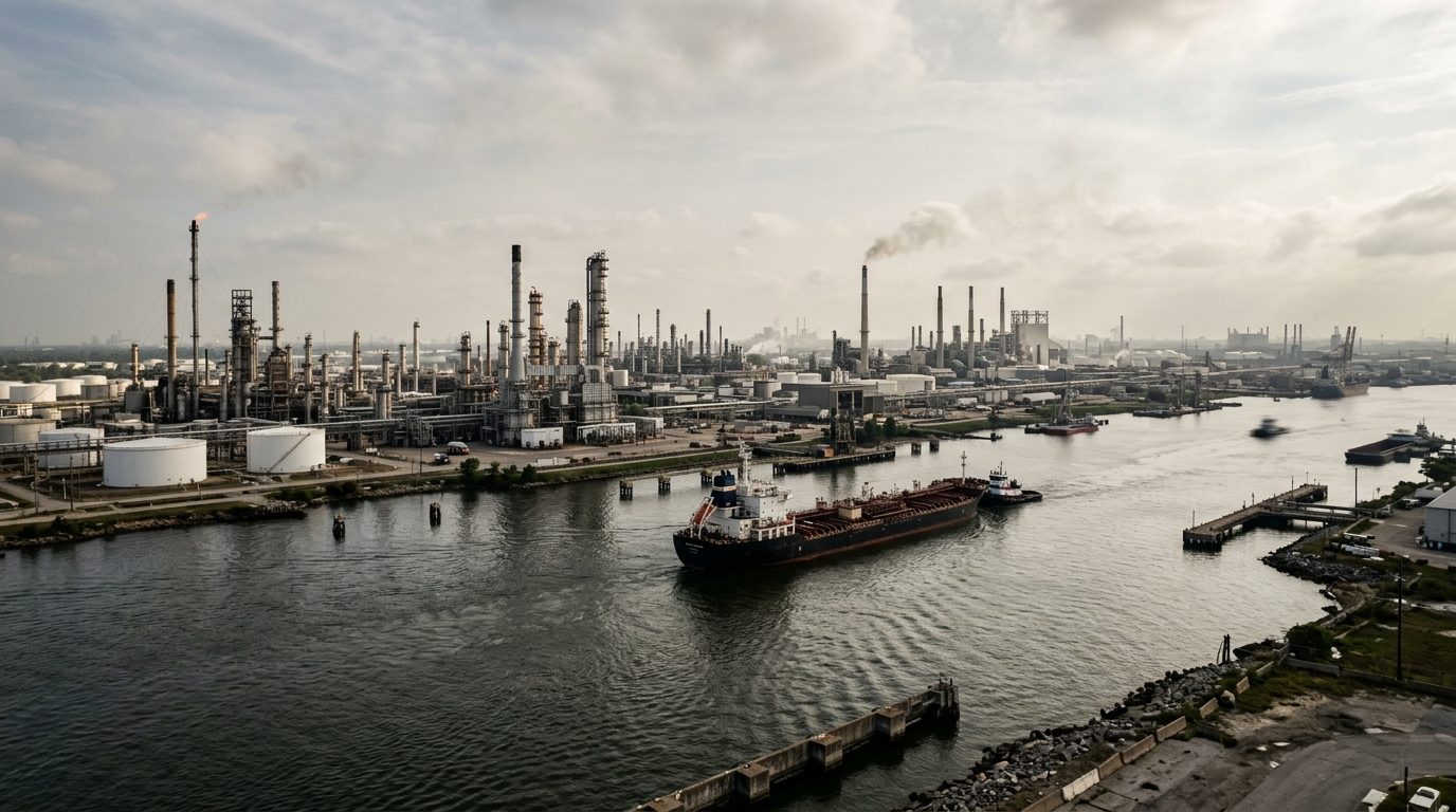
The Beaumont-Port Arthur metro occupies the flat coastal plain of far southeast Texas, where the Neches and Sabine rivers meet Sabine Lake and drain to the Gulf of Mexico through the Sabine-Neches Waterway. It spans three counties: Jefferson, home to Beaumont and Port Arthur along the waterway; Orange, bordering Louisiana along the Sabine River; and Hardin, which rises from the coastal plain into the pine and hardwood forest of the Big Thicket. This geography shapes the housing stock. The older core cities have street grids from the early to mid-20th century, filled with wood-frame bungalows, brick ranches, and postwar cottages predating modern elevation and drainage codes. Newer subdivisions ring the metro’s outer edges in Lumberton, Nederland, Vidor, and Bridge City, where slab-on-grade brick homes on larger, flatter lots have gone up since the 1990s. Manufactured and modular housing is common across rural Hardin and Orange counties.
Within the metro, price tiers track distance from industrial waterfront and low-lying, flood-prone ground more than any single dividing line. Established residential areas near downtown Beaumont, along the Calder Avenue corridor, and in the city’s western neighborhoods carry a premium tied to mature tree canopy, historic architecture, and proximity to Lamar University and the medical district. Newer subdivisions in Lumberton and parts of Nederland and Bridge City also sit toward the upper end, reflecting newer construction and distance from refinery and port operations. Lower-priced housing concentrates in older neighborhoods nearest the ship channel and refinery complexes in Port Arthur and south Beaumont, in pockets prone to street flooding, and in smaller rural communities with older housing stock.
The regional economy is built on petrochemical refining, manufacturing, and marine transportation, a legacy of the 1901 Spindletop oil discovery near Beaumont that made the area one of the largest concentrations of refineries and chemical plants in the country. Motiva Enterprises operates its Port Arthur refinery, among the largest crude-processing facilities in North America, and ExxonMobil, Valero, and other refiners and chemical producers, including a major steam-cracker complex, maintain large operations across Jefferson and Orange counties. The Port of Beaumont and the Port of Port Arthur move heavy tonnage and support logistics employment. Beyond energy, the economy runs on healthcare systems including CHRISTUS Southeast Texas and Baptist Hospitals of Southeast Texas, education anchored by Lamar University, retail and trade, and government employment.
Several local factors distinguish this metro for buyers. The region sits in the Gulf hurricane corridor and has absorbed repeated storm damage, including from Rita, Ike, Harvey, and Laura, with flat terrain that drains slowly and produces flash flooding even outside named storms; flood zone status, elevation certificates, and flood insurance cost should be checked parcel by parcel rather than assumed from a neighborhood’s reputation. Texas has no state income tax, but property tax rates are a meaningful ongoing cost that varies by city, school district, and any special districts attached to newer subdivisions. Public transit is limited and most residents rely on personal vehicles, so commute distance to refineries, ports, or hospitals is worth weighing. Because much of the metro sits close to active industrial facilities, buyers should research a property’s proximity to plants, pipelines, and rail lines and any applicable zoning restrictions. In newer master-planned subdivisions, buyers should confirm HOA rules, dues, and utility district assessments layered on top of property taxes.
Cities and Towns in the Beaumont Metro Area
Notable Communities and Neighborhoods
Beaumont Real Estate Market FAQ
How is the Beaumont-Port Arthur housing market organized geographically?
The metro covers three counties along the Neches and Sabine rivers and Sabine Lake. Jefferson County holds the urban core of Beaumont and Port Arthur along the industrial waterway; Orange County sits along the Sabine River on the Louisiana border; and Hardin County extends north from the flat coastal plain into the forested Big Thicket. Older, denser neighborhoods cluster in the core cities, while newer subdivisions have grown up in outlying towns such as Lumberton, Nederland, Vidor, and Bridge City.
Which areas in the metro tend to be pricier, and why?
Established neighborhoods near downtown Beaumont and the Calder Avenue corridor, along with newer subdivisions in Lumberton and parts of Nederland and Bridge City, tend to sit toward the higher end. These areas combine either historic housing stock and mature tree canopy or newer construction on elevated, flatter lots set back from refinery and port operations. Areas closest to the ship channel, refinery complexes, and low-lying, flood-prone ground tend to carry lower prices.
What should buyers verify locally before purchasing in this metro?
Buyers should check a property’s FEMA flood zone designation and elevation certificate, confirm flood insurance availability and cost directly with an agent or the National Flood Insurance Program, review the applicable property tax rate across city, county, school district, and any municipal utility district, and confirm whether a subdivision carries HOA dues or special district assessments. Proximity to refineries, chemical plants, pipelines, and rail lines is also worth researching parcel by parcel.
What is the region’s exposure to hurricanes and flooding?
The metro sits in the Gulf hurricane corridor and has sustained repeated storm damage over the past two decades, including from Hurricanes Rita, Ike, Harvey, and Laura. The terrain across Jefferson and Orange counties is largely flat and drains slowly, which produces localized flash flooding even during heavy rain events that fall short of a named storm. Flood risk varies significantly by specific parcel rather than by city as a whole, so local flood zone and drainage history should be checked directly.
Nearby Markets